I am a Seller
Guidelines and Best Practices
The following list provides guidelines and best practices to follow when gathering your Building List data for configuration and import into “The Connected World”:
Download a sample file from My Buildings to create an initial Building List import document.
Provide both OCN and ICSC attributes, if available, for configuration.
Identify all building types/categories. If building category is left unidentified, TCW will provide the building category based on Connectbase proprietary market data. If there is no match, it will default to Commercial Building.
A single building can have multiple categories, however, they must each be separated by a comma with no spaces in between.
Identify OnNet and Near Net buildings.
Determine the install intervals for OnNet and Near Net Ethernet and/or Wavelength-enabled buildings.
Identify the products you offer from each building or across your network.
When entering building addresses, use a leading capital letter followed by trailing lowercase characters.
Verify that address directions are properly formatted. For example, 100 W Main St versus 100 Main St W.
Assure that directional addresses include a latitude and longitude as appropriate to wireless towers that are not USPS addressable locations.
While not required, it is recommended that you provide latitude and longitude data whenever possible to avoid addresses that cannot be geocoded, especially for wireless towers.
Verify that you have documented all required data elements according to your application.
For specific distribution format requirements, refer to the appropriate Distribution Format Reference Guide.
Upon request, Connectbase can create custom text-based fields to be populated into your building list. Contact Customer Support for details.
If sending or receiving lists via Network Radar, inform Connectbase if you have included required custom (non-standard) fields.
Working with My Locations
The Function provides you with a listing of the locations/buildings that are currently in your customer instance. From a location perspective, everything that you can visualize on the map is managed and loaded from .
When you click the  sign to the left of a building, the core building record displays where you can view the basic building information, as well as Building Manager information, Building Intelligence (tenant data), and Network Intelligence (carrier data).
Note
Some of the data options described above may not be available in your viewing area. Your view of data is dependent on the modules purchased as well as your defined user access privileges.
When you click the on the navigation bar, the My Locations page displays as shown in the sample screen below.
 |
Customizing your view
Within My Locations, My Routes, and Quoting, you can customize your view of grid data and save the view for future use.
Managing your grid data enables you to:
Acting on a location(s)
Use the  Actions menu (vertical ellipsis) to perform actions on a selected address(es). Some actions on the menu are unavailable (dimmed) until you have selected an address or addresses to act on.
To act on all addresses in the building list, select the checkbox that displays at the top of the list to select all locations in the list.
Note
Administrator privileges are required to perform Export Selected and Export All functions. Edit User privileges (or greater) are required to perform the Import function
 |
Data Dictionary Elements
The data elements needed to populate the Building List for successful import are group in three main sections: Required elements, Required based on special considerations, and Optional Elements.
About My Routes
The “My Routes” function is for uploading, adding, and editing routes. Routes are the physical fiber routes that you have loaded into your entity.
There are three types of routes:
Instance routes – These are company-level routes, and anyone who has access to the instance can view them.
Saved routes – These routes are your personal routes that you create or upload and are only visible to you.
Published routes – These routes are any of your saved routes that you choose to publish so that other users of your instance can also view them, but they cannot edit them.
Note
In addition to (or instead of) using the My Routes function to manage your routes, you can use the My Layers function to create your own hierarchical folder structure and upload route files to better organize and maintain data that is specific to your needs and business role. See “Working with My Layers” for details.
Click on navigation bar to access My Routes.
Result: This displays list of existing routes in your instance as shown in the below example:
 |
Click the '+' sign to expand an existing route. The route information displays as below:
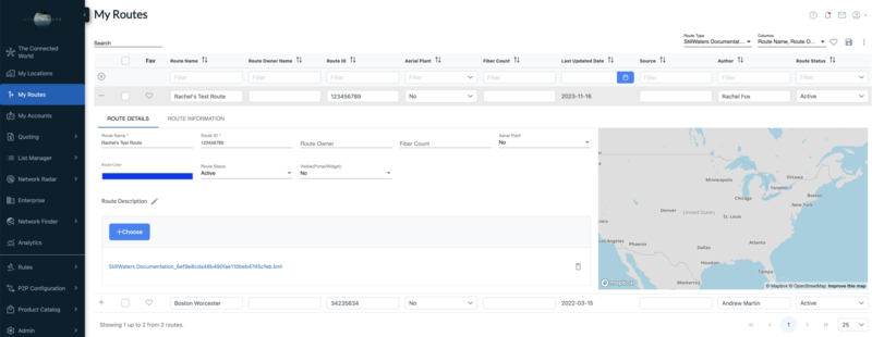 |
You can use this page to update/edit the route information of existing routes, including route color. You can also replace the existing route file by clicking on the "Choose" button and update the route displayed on the map.
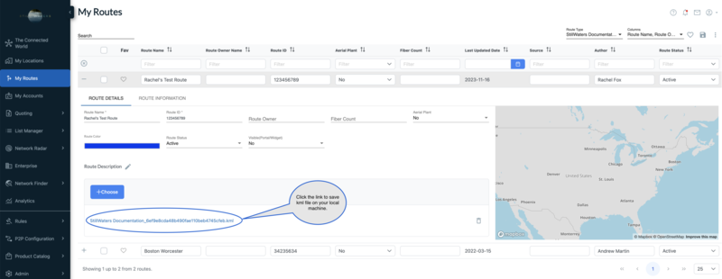
Exporting an existing route:
You can export the existing route's kml file by clicking on the the link shown in the below example. This option lets you save the route file on your local machine.
 |
Routes can be added in either KML or KMZ format. You can add routes in one of two ways:
You can add routes to your instance
You can add routes as your saved routes.
To add a route(s):
Click the from the navigation sidebar.
Result: The My Routes page displays. If routes have already been added to the instance, they are displayed in a list here and include the following data fields:
Route Name – (required) A unique name given to identify the route
Route ID – (required) A user defined route id to be used as an identifier for the route.
Route Owner – (optional) Enter the name of the route owner.
Fiber Count – (optional) Enter a numeric count for the fiber route
Aerial Plant – (optional) Yes/No. Aerial plant is a fiber network, or any type of access medium, that is built above the ground on poles. The most common poles are telephone poles and electric utility poles.
Route Color – (optional) See Color coding your routes.
Route Status – (optional) From the dropdown list, select from the following options: Active, Competitive, In Progress, Partner, Planned, Sold,
Visible (Portal/Widget) – (optional) Yes/No
From the My Routes page, click the
 add icon located in the bottom right corner of the page.
Result: The following icons display enabling you to add to <Instance Name> Routes or Saved Routes.

Do one of the following:
Click the star icon to add a route(s) to your Saved Routes.
Click the circle icon to add a route(s) to the <Instance Name>.

On the Routes page, click the + button.
Complete these required user defined fields:
– (required) A unique name given to identify the route.
– (required) A user defined route id to be used as an identifier for the route.
All remaining fields are optional.
From your local directory, double click on the route file you want to upload.
Result: The selected route file is uploaded.
If you want others in the instance to view your Saved Route, click the toggle.
Result: The Publish Route toggle changes to blue to indicate selection.
From the My Routes page, you can manage your view of route data in the same way that you can for My Locations.
About My Layers
The My Layers module enables you to create your own hierarchical folder structure and upload data sets (Links, Points, Addresses, Lat/Longs), enabling you to better organize and maintain the data you need for your specific business role.
My Layers enables you to perform these functions:
Create/name/rename/delete folders for layer data
Nest folders
Enable folders (and child folders) to view data in TCW
Select marker type for points and color for routes and boundaries
Supported file types include the following: KML, KMZ, GEOJSON, CSV, SHAPE.*
Lat/Long CSV file should have longitude, latitude columns*
Address CSV file should have Address, City, State columns (Zipcode optional)*.
Shape/Boundary file as zip format (must have .SHP, .SHX and .DXF files) files.
Asterisk * in the import file format indicates a requirement.
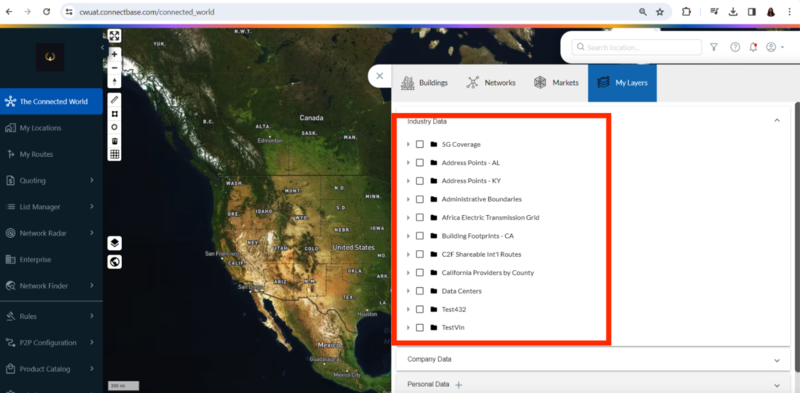
Within My Layers, there are three types of data layers available for viewing:
– Data that is supplied by Connectbase
– Data that is shared by another user within your instance and is thereby viewable to all users of the instance
– Data that is viewable only to you unless you choose to share it with the other users of the instance. Prior to sharing layers to a user group, the user group must have been preconfigured in . Refer to Configuring User Groups for details about how to configure User Groups.
Managing data layers effectively is crucial for maintaining accurate network and service boundaries. This guide covers best practices for data cleaning and labeling. Following these guidelines helps to minimize errors and keep information standardized across internal and customer-facing environments.
Step by Step Guide
Geometry cleanup is about ensuring that the data representing network routes or boundary is clean and accurate. This process includes:
Make sure that there are no duplicate routes or unnecessary details that could confuse users.
Confirm that data aligns with the geography to provide accurate representation.
Maintaining consistent and clear naming conventions for network routes and service boundaries.
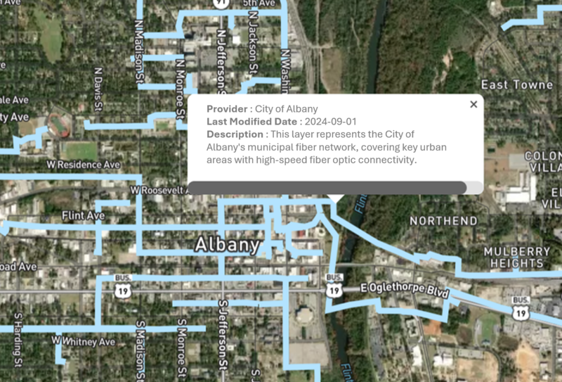
: Ensure that the provider name is clearly visible in the label for easy identification.
Best Practices
Provider: City of Albany
Last Modified Date: 2024-09-01
Description: This layer represents the City of Albany's municipal fiber network, covering key urban areas with high-speed fiber optic connectivity.
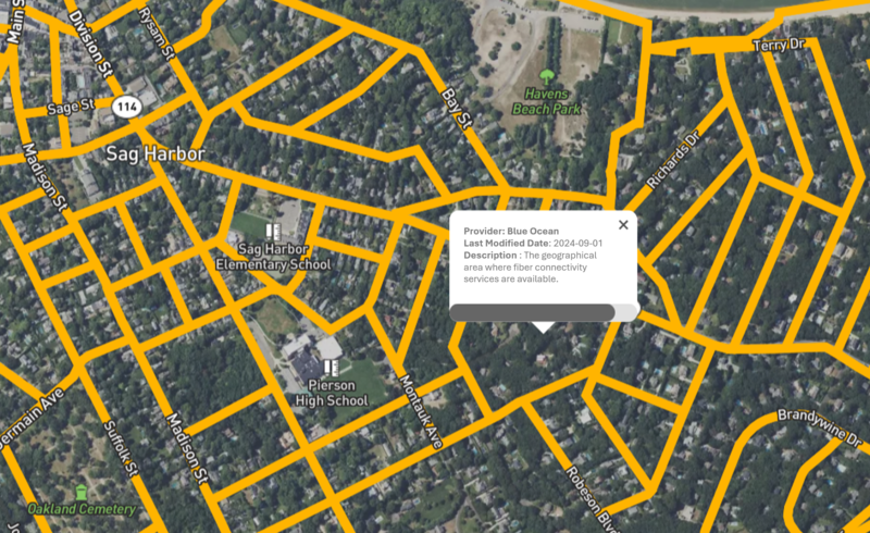
Provider: Blue Ocean
Last Modified Date: 2024-09-01
Description: The geographical area where fiber connectivity services are available.
FAQs
Data cleaning refers to the process of removing unnecessary or duplicate data from a network route or service boundary file. It includes verifying serviceability accuracy, simplifying geometry where needed, and making sure only relevant and up-to-date information is included. This ensures that the data is easy to use, navigate, and integrate with other layers.
Including the provider name in the label makes it easier for users to identify service provider and quickly assess the data source for a particular route. This transparency reduces ambiguity, especially when multiple layers are turned on in My Layer, and ensures that users have all the relevant context at a glance.
To access My Layers:
Click from the navigation sidebar.
Click the
 located in the blue header banner at the top of the page.
Click .
Result: Following screen appears containing My Layers folders in alphabetical order.
To create folders and subfolders:
Click from the navigation sidebar.
Click the
located in the blue header banner at the top of the page.Click .
In the Personal Data field, click the
.On the pop-up screen, give the folder a name. Click .
Result: The newly added folder now displays in the folder list. Beside the folder name, the following three icons display: pencil icon (edit), + icon (add), and trash icon (delete).
Click the
(add) icon to create a subfolder within this folder or to upload a file into the folder.To create a subfolder from the pop-up menu, select the radio button (default).
Result: The newly added subfolder now displays in the hierarchy.
To import data into the folder, select the radio button, then select the file to be imported from your local drive.
Result: The file is imported into the selected folder.
To import files in folders/ subfolders:
Select the name of the folder for the imported file to reside.
Click the
.On the pop-up dialog box, click the radio button.
Result: On the File pop-up dialog box, the list of supported file types is listed.
Click the button to locate and select the file for import.
Click . Once the import completes, the file name displays within the selected folder/subfolder.
Once you have imported files into your folders, you can select/deselect files that you want to view on the map.
For example, suppose you added a folder named “Routes” that contains all your route files. You can click on the Routes folder and select/deselect the specific route files you want to view on the map.
Click the containing the files you want to view.
Select/deselect the files for viewing on the map.
Note
The order in which you turn on the files is the order in which they display on the map.
To edit a folder name:
Select the name of the folder you wish to edit.
Click the
 .
.On the pop-up dialog box, type a new name for the folder.
Click the button. The edited file name appears in the folder structure.
Currently, when you select edit for a specific file, you can only edit the color scheme that appears on the map for the file you selected.
When sharing a data layer, you can apply a specific User Group to the data layer, thereby limiting which users have access to the layer.
To edit files and share folders:
Select the folder that contains the file you want to edit and/or share.
Click the file name.
Click the
.On the pop-up dialog box, edit the file name and/or toggle the radio button (Off/dimmed when disabled; On/highlighted in blue when enabled) to indicate if you want to share the file.
Where applicable, in the User Groups section, select a user group in which to share the folder.
Click the button.
To delete a folder from the My Layers folder structure:
Select the name of the folder you wish to delete.
Click the
 .
.
The table below provides descriptions of the industry layers available in Blue Ocean Instance of TCW.
INDUSTRY_LAYER_NAME | LAYER_TYPE | DEFINITION |
|---|---|---|
5G Coverage | polygon | Areas covered by 5G wireless network technology. |
Address Points - AK | point | Geographic locations of address points in Alaska. |
Address Points - AL | point | Geographic locations of address points in Alabama. |
Address Points - AR | point | Geographic locations of address points in Arkansas. |
Address Points - AZ | point | Geographic locations of address points in Arizona. |
Address Points - Austria | point | Geographic locations of address points in Austria. |
Address Points - BMU | point | Geographic locations of address points in Bermuda. |
Address Points - Bahamas | point | Geographic locations of address points in the Bahamas. |
Address Points - Brazil | point | Geographic locations of address points in Brazil. |
Address Points - CA | point | Geographic locations of address points in California. |
Address Points - CO | point | Geographic locations of address points in Colorado. |
Address Points - CT | point | Geographic locations of address points in Connecticut. |
Address Points - DC | point | Geographic locations of address points in Washington, D.C. |
Address Points - DE | point | Geographic locations of address points in Delaware. |
Address Points - FL | point | Geographic locations of address points in Florida. |
Address Points - Faroe Islands | point | Geographic locations of address points in the Faroe Islands. |
Address Points - GA | point | Geographic locations of address points in Georgia. |
Address Points - HI | point | Geographic locations of address points in Hawaii. |
Address Points - IA | point | Geographic locations of address points in Iowa. |
Address Points - ID | point | Geographic locations of address points in Idaho. |
Address Points - IL | point | Geographic locations of address points in Illinois. |
Address Points - IN | point | Geographic locations of address points in Indiana. |
Address Points - Israel | point | Geographic locations of address points in Israel. |
Address Points - Jamaica | point | Geographic locations of address points in Jamaica. |
Address Points - KS | point | Geographic locations of address points in Kansas. |
Address Points - KY | point | Geographic locations of address points in Kentucky. |
Address Points - LA | point | Geographic locations of address points in Louisiana. |
Address Points - MA | point | Geographic locations of address points in Massachusetts. |
Address Points - MD | point | Geographic locations of address points in Maryland. |
Address Points - ME | point | Geographic locations of address points in Maine. |
Address Points - MI | point | Geographic locations of address points in Michigan. |
Address Points - MN | point | Geographic locations of address points in Minnesota. |
Address Points - MO | point | Geographic locations of address points in Missouri. |
Address Points - MS | point | Geographic locations of address points in Mississippi. |
Address Points - MT | point | Geographic locations of address points in Montana. |
Address Points - NC | point | Geographic locations of address points in North Carolina. |
Address Points - ND | point | Geographic locations of address points in North Dakota. |
Address Points - NE | point | Geographic locations of address points in Nebraska. |
Address Points - NH | point | Geographic locations of address points in New Hampshire. |
Address Points - NJ | point | Geographic locations of address points in New Jersey. |
Address Points - NM | point | Geographic locations of address points in New Mexico. |
Address Points - NV | point | Geographic locations of address points in Nevada. |
Address Points - NY | point | Geographic locations of address points in New York. |
Address Points - OH | point | Geographic locations of address points in Ohio. |
Address Points - OK | point | Geographic locations of address points in Oklahoma. |
Address Points - OR | point | Geographic locations of address points in Oregon. |
Address Points - PA | point | Geographic locations of address points in Pennsylvania. |
Address Points - PR | point | Geographic locations of address points in Puerto Rico. |
Address Points - RI | point | Geographic locations of address points in Rhode Island. |
Address Points - SC | point | Geographic locations of address points in South Carolina. |
Address Points - SD | point | Geographic locations of address points in South Dakota. |
Address Points - Spain | point | Geographic locations of address points in Spain. |
Address Points - TN | point | Geographic locations of address points in Tennessee. |
Address Points - TX | point | Geographic locations of address points in Texas. |
Address Points - UAE | point | Geographic locations of address points in the United Arab Emirates. |
Address Points - UT | point | Geographic locations of address points in Utah. |
Address Points - VA | point | Geographic locations of address points in Virginia. |
Address Points - VT | point | Geographic locations of address points in Vermont. |
Address Points - Virgin Islands | point | Geographic locations of address points in the U.S. Virgin Islands. |
Address Points - WA | point | Geographic locations of address points in Washington. |
Address Points - WI | point | Geographic locations of address points in Wisconsin. |
Address Points - WV | point | Geographic locations of address points in West Virginia. |
Address Points - WY | point | Geographic locations of address points in Wyoming. |
Address Points Canada | point | Geographic locations of address points across Canada. |
Administrative Boundaries | polygon | Boundaries defining administrative divisions like countries, states, or municipalities. |
Africa Electric Power Transmission Line | line | Locations of electric power transmission lines across Africa. |
Africa Electric Transmission Grid | line | A network map of electric transmission infrastructure in Africa. |
Alabama IP Data | point | Internet Protocol (IP) address or infrastructure data specific to Alabama. |
All Public Libraries | point | Locations and details of public libraries. |
American Indian and Alaska Native Lands | polygon | Geographic areas designated as American Indian or Alaska Native lands. |
Australia Electric Power Transmission Lines | line | Locations of electric power transmission lines in Australia. |
Awarded CBSA | polygon | Metropolitan Statistical Areas (CBSAs) awarded funding or recognition for projects. |
Biodiesel PLant | point | Locations of facilities producing biodiesel. |
Broadband Availability | point | Geographic regions where broadband internet service is available. |
Broadband Coverage | polygon | Areas covered by broadband internet service providers. |
Broadband Data | line | Information related to broadband internet service, including availability and speed. |
Building Footprints - AK | polygon | Perimeter outlines of buildings in Alaska. |
Building Footprints - AL | polygon | Perimeter outlines of buildings in Alabama. |
Building Footprints - AR | polygon | Perimeter outlines of buildings in Arkansas. |
Building Footprints - AZ | polygon | Perimeter outlines of buildings in Arizona. |
Building Footprints - CA | polygon | Perimeter outlines of buildings in California. |
Building Footprints - CO | polygon | Perimeter outlines of buildings in Colorado. |
Building Footprints - CT | polygon | Perimeter outlines of buildings in Connecticut. |
Building Footprints - Canada | polygon | Perimeter outlines of buildings across Canada. |
Building Footprints - DC | polygon | Perimeter outlines of buildings in Washington, D.C. |
Building Footprints - DE | polygon | Perimeter outlines of buildings in Delaware. |
Building Footprints - FL | polygon | Perimeter outlines of buildings in Florida. |
Building Footprints - GA | polygon | Perimeter outlines of buildings in Georgia. |
Building Footprints - IA | polygon | Perimeter outlines of buildings in Iowa. |
Building Footprints - ID | polygon | Perimeter outlines of buildings in Idaho. |
Building Footprints - IL | polygon | Perimeter outlines of buildings in Illinois. |
Building Footprints - IN | polygon | Perimeter outlines of buildings in Indiana. |
Building Footprints - KS | polygon | Perimeter outlines of buildings in Kansas. |
Building Footprints - KY | polygon | Perimeter outlines of buildings in Kentucky. |
Building Footprints - LA | polygon | Perimeter outlines of buildings in Louisiana. |
Building Footprints - MA | polygon | Perimeter outlines of buildings in Massachusetts. |
Building Footprints - MD | polygon | Perimeter outlines of buildings in Maryland. |
Building Footprints - ME | polygon | Perimeter outlines of buildings in Maine. |
Building Footprints - MI | polygon | Perimeter outlines of buildings in Michigan. |
Building Footprints - MN | polygon | Perimeter outlines of buildings in Minnesota. |
Building Footprints - MO | polygon | Perimeter outlines of buildings in Missouri. |
Building Footprints - MS | polygon | Perimeter outlines of buildings in Mississippi. |
Building Footprints - MT | polygon | Perimeter outlines of buildings in Montana. |
Building Footprints - NC | polygon | Perimeter outlines of buildings in North Carolina. |
Building Footprints - ND | polygon | Perimeter outlines of buildings in North Dakota. |
Building Footprints - NE | polygon | Perimeter outlines of buildings in Nebraska. |
Building Footprints - NH | polygon | Perimeter outlines of buildings in New Hampshire. |
Building Footprints - NJ | polygon | Perimeter outlines of buildings in New Jersey. |
Building Footprints - NM | polygon | Perimeter outlines of buildings in New Mexico. |
Building Footprints - NV | polygon | Perimeter outlines of buildings in Nevada. |
Building Footprints - NY | polygon | Perimeter outlines of buildings in New York. |
Building Footprints - NYC | polygon | Perimeter outlines of buildings in New York City. |
Building Footprints - OH | polygon | Perimeter outlines of buildings in Ohio. |
Building Footprints - OK | polygon | Perimeter outlines of buildings in Oklahoma. |
Building Footprints - OR | polygon | Perimeter outlines of buildings in Oregon. |
Building Footprints - PA | polygon | Perimeter outlines of buildings in Pennsylvania. |
Building Footprints - RI | polygon | Perimeter outlines of buildings in Rhode Island. |
Building Footprints - SC | polygon | Perimeter outlines of buildings in South Carolina. |
Building Footprints - TN | polygon | Perimeter outlines of buildings in Tennessee. |
Building Footprints - TX | polygon | Perimeter outlines of buildings in Texas. |
Building Footprints - UK | polygon | Perimeter outlines of buildings in the United Kingdom. |
Building Footprints - UT | polygon | Perimeter outlines of buildings in Utah. |
Building Footprints - VA | polygon | Perimeter outlines of buildings in Virginia. |
Building Footprints - VT | polygon | Perimeter outlines of buildings in Vermont. |
Building Footprints - WA | polygon | Perimeter outlines of buildings in Washington. |
Building Footprints - WI | polygon | Perimeter outlines of buildings in Wisconsin. |
Building Footprints - WV | polygon | Perimeter outlines of buildings in West Virginia. |
Building Footprints - WY | polygon | Perimeter outlines of buildings in Wyoming. |
Building Symbols - Canada | point | Symbols and icons representing various types of buildings across Canada. |
C2F MS Building Points | point | Points representing building locations for Mississippi. |
C2F Shareable Int'l Routes | line | International routes that can be shared within Connectbase network. |
C2F Shareable Microwave | line | Microwave link locations that can be shared within Connectbase network. |
C2F Shareable Subsea Routes | line | Subsea communication routes that can be shared within Connectbase network. |
C2F Shareable US Routes | line | US routes that can be shared within Connectbase network. |
CA - Ontario - Parcels | polygon | Parcel boundaries for properties in Ontario, Canada. |
Cable Landing Stations | point | Locations where undersea cables come ashore. |
California Providers by City | polygon | Internet or telecom service providers by city in California. |
California Providers by County | polygon | Internet or telecom service providers by county in California. |
California Providers by MSA | polygon | Internet or telecom service providers by Metropolitan Statistical Area in California. |
Canadian Electric Power Transmission Lines | line | Locations of electric power transmission lines in Canada. |
Canadian National Broadband | polygon | National broadband infrastructure and coverage in Canada. |
Central Offices | point | Locations of central telephone exchanges or data centers. |
Child Care Facilities | point | Locations of facilities providing child care services. |
Cloud Onramps | point | Locations of cloud service onramps or data centers. |
Colleges & Universities | point | Locations of higher education institutions. |
Colleges & University | point | Locations of higher education institutions (alternate naming). |
Cologix Data Centers | point | Data center locations managed by Cologix. |
Connecticut | polygon | Geographic and infrastructure data for Connecticut. |
Connecticut - IP Data | point | Internet Protocol (IP) address or infrastructure data specific to Connecticut. |
Connecting Minority Communities - Anchor Community Eligibility | point | Designated communities eligible for funding to improve connectivity and services. |
Countries of the World | point | Geographic data for countries around the world. |
DMA Boundary | polygon | Designated Market Area boundaries for media and advertising purposes. |
Dark Fiber | line | Locations of unused fiber optic cables available for leasing. |
Data Centers | point | Locations of facilities housing servers and data storage. |
Drilling Platforms | point | Locations of offshore or onshore drilling platforms. |
EPA Superfund Sites | point | Locations of hazardous waste sites designated for cleanup by the EPA. |
Electric Substations | point | Locations of facilities where electrical power is transformed or distributed. |
Ethanol Plants | point | Locations of facilities producing ethanol. |
FCC Connect America Fund Areas | polygon | Areas designated for funding under the FCC's Connect America Fund for broadband expansion. |
FCC Rural Digital Opportunity Fund Auction by Bidder | polygon | Auction data for the Rural Digital Opportunity Fund, including bidders and winning bids. |
FCC Rural Digital Opportunity Fund Eligible Areas | polygon | Areas eligible for funding under the Rural Digital Opportunity Fund. |
Fiber Regeneration Huts | point | Locations of facilities where optical fiber signals are regenerated. |
Fictitious Business Name Statements | point | Locations of businesses registered under fictitious names. |
Financial Exchange | point | Locations of financial market exchanges. |
Financial Services Sites | point | Locations of institutions providing financial services. |
Fixed Broadband Deployment | polygon | Data on the deployment and availability of fixed broadband services. |
Florida - Municipalities | polygon | Municipal boundaries and data for Florida. |
Fortune 500 Headquarters | point | Locations of the headquarters of Fortune 500 companies. |
France - Building Footprints | line | Perimeter outlines of buildings in France. |
Global Networks Country Sum | polygon | Aggregated network data by country globally. |
Global Networks by City | polygon | Network data by city globally. |
Global Power Plants | point | Locations of power plants worldwide. |
Global Teleport Sites | point | Locations of teleport (satellite ground station) facilities worldwide. |
Global Tower Points | point | Locations of telecommunications towers globally. |
Government Sites | point | Locations of various government buildings and facilities. |
Gulf of Mexico Oil and Gas Platforms | point | Locations of oil and gas platforms in the Gulf of Mexico. |
HOA | polygon | Homeowners' Association locations or boundaries. |
Healthcare Sites | point | Locations of facilities providing healthcare services. |
Hospitals | point | Locations of hospitals. |
IP Data Fulton County, GA | point | Internet Protocol (IP) address or infrastructure data for Fulton County, Georgia. |
IP Data Walker County, GA | point | Internet Protocol (IP) address or infrastructure data for Walker County, Georgia. |
IQ Fiber_Alabama | point | Fiber infrastructure data for Alabama. |
IQ Fiber_Florida | line | Fiber infrastructure data for Florida. |
IQ Fiber_Georgia | line | Fiber infrastructure data for Georgia. |
IQ Fiber_North Carolina | point | Fiber infrastructure data for North Carolina. |
IQ Fiber_South Carolina | point | Fiber infrastructure data for South Carolina. |
IQ Fiber_Tennessee | point | Fiber infrastructure data for Tennessee. |
Industry Park - KY | polygon | Locations of industry parks in Kentucky. |
Internal map-KFN | line | Internal mapping data for KFN (specific organization). |
Internet Provider | point | Locations and data for internet service providers. |
LATA | polygon | Local Access and Transport Area boundaries for telecommunications. |
LEC & PTT Boundary | polygon | Boundaries for Local Exchange Carriers (LEC) and Public Telephone and Telegraph (PTT) networks. |
Land Use & Zoning | polygon | Data on land use and zoning regulations. |
MSA's | polygon | Metropolitan Statistical Areas data. |
MSO Boundary | polygon | Boundaries for Multiple System Operators in cable or telecommunications. |
MTSO | point | Mobile Telephone Switching Office locations. |
Manufacturing Sites | point | Locations of manufacturing facilities. |
Military Bases | point | Locations of military bases. |
Mobile Teleco Poletop Installation Locations | point | Locations of mobile telecommunications installations on utility poles. |
Municipalities - Canada | polygon | Municipal boundaries and data for Canada. |
NNA-Highway-Crossing | line | Locations where highways cross other infrastructure like railroads or rivers. |
NNA-Historical-District | polygon | Locations of designated historical districts. |
NNA-Railroad-Crossing | line | Locations where railroads cross other infrastructure like highways or rivers. |
NNA-River-Crossing | point | Locations where rivers cross other infrastructure like highways or railroads. |
National Heritage List for England | polygon | Locations listed as national heritage sites in England. |
Natural Disaster Data | point | Data on locations and impacts of natural disasters. |
Natural Disasters | point | Geographic data related to natural disasters. |
Natural Gas Processing Plant | point | Locations of facilities processing natural gas. |
Natural Gas Storage | point | Locations of natural gas storage facilities. |
North American Skyscrapers | point | Locations of skyscrapers in North America. |
Not For Profit Sites | point | Locations of non-profit organization sites. |
Nursing Homes | point | Locations of nursing homes. |
Oil & Gas | point | Locations related to oil and gas extraction and processing. |
Oil Refineries | point | Locations of oil refining facilities. |
Oil and Natural Gas Wells | point | Locations of oil and natural gas wells. |
Parcels - Bahamas | point | Parcel boundaries for properties in the Bahamas. |
Parcels - US - AK | polygon | Parcel boundaries for properties in Alaska, USA. |
Parcels - US - FL - City - Jacksonville | polygon | Parcel boundaries for properties in Jacksonville, Florida, USA. |
Parcels - US - MA - City - Abington | polygon | Parcel boundaries for properties in Abington, Massachusetts, USA. |
Parcels - US - MA - City - Boston | polygon | Parcel boundaries for properties in Boston, Massachusetts, USA. |
Parcels - US - MA - City - Cambridge | polygon | Parcel boundaries for properties in Cambridge, Massachusetts, USA. |
Peering Exchange Facilities | point | Locations of facilities for peering exchanges (network interconnections). |
Peering Locations - Africa | point | Locations of peering exchange facilities in Africa. |
Places of Worship | point | Locations of places of worship (churches, mosques, temples, etc.). |
Points of Interest | point | Locations of notable landmarks, attractions, or points of interest. |
Private Network Routes | line | Routes for private telecommunications networks. |
Private Schools | point | Locations of private educational institutions. |
Pubic School Sites | point | Locations of public educational institutions. |
Public School Sites | point | Locations of public educational institutions (alternate naming). |
ROW impediments | point | Locations of obstacles or impediments along Rights of Way (ROW). |
Railroad Right of Way | line | Locations of railroad rights of way. |
Right of Way - Highway | line | Locations of highway rights of way. |
Road ROW - CAN | line | Rights of way for roads in Canada. |
Road ROW - US | line | Rights of way for roads in the USA. |
Road Right of Way | line | General data on road rights of way. |
Routes Prediction By City_VA | point | Predicted routes and transportation data by city in Virginia. |
Small Cell Sites | point | Locations of small cell towers or infrastructure. |
Solar Power | point | Locations of solar power generation facilities. |
South Carolina - Municipalities | polygon | Municipal boundaries and data for South Carolina. |
St Lucia County Data | polygon | Geographic and infrastructure data for St Lucia County. |
Street Lighting Poles | point | Locations of street lighting poles. |
Summit Broadband - GIS Data | point | GIS data related to Summit Broadband services. |
Summit Broadband - Parcels - Collier County | polygon | Parcel boundaries related to Summit Broadband services in Collier County, Florida. |
Summit Broadband - Parcels - Lake County | polygon | Parcel boundaries related to Summit Broadband services in Lake County, Florida. |
Summit Broadband - Parcels - Lee County | polygon | Parcel boundaries related to Summit Broadband services in Lee County, Florida. |
Summit Broadband - Parcels - Orange County | polygon | Parcel boundaries related to Summit Broadband services in Orange County, Florida. |
Summit Broadband - Wireless - FL | point | Wireless network data for Summit Broadband in Florida. |
Texas Providers by City | polygon | Internet or telecom service providers by city in Texas. |
Texas Providers by County | polygon | Internet or telecom service providers by county in Texas. |
Texas Providers by MSA | polygon | Internet or telecom service providers by Metropolitan Statistical Area in Texas. |
Traffic Signals | point | Locations of traffic signals. |
US - AZ - Building Footprints | polygon | Perimeter outlines of buildings in Arizona, USA. |
US - CA - Building Footprints | polygon | Perimeter outlines of buildings in California, USA. |
US - DC - Building Footprints | polygon | Perimeter outlines of buildings in Washington, DC, USA. |
US - EPA Sites | point | Locations of sites managed or regulated by the Environmental Protection Agency (EPA) in the USA. |
US - FL - Building Footprints | polygon | US - FL - Building Footprints |
US - GA - Building Footprints | polygon | US - GA - Building Footprints |
US - IL - Building Footprints | polygon | US - IL - Building Footprints |
US - MA - City - Boston Building Footprints | polygon | US - MA - City - Boston Building Footprints |
US - ME - Building Footprints | polygon | US - ME - Building Footprints |
US - MN - County Land Use | polygon | US - MN - County Land Use |
US - MS - Building Footprints | polygon | US - MS - Building Footprints |
US - NC - Building Footprints | polygon | US - NC - Building Footprints |
US - NC - Parcels | point | US - NC - Parcels |
US - PA - Building Footprints | polygon | US - PA - Building Footprints |
US - VT - Building Footprints | polygon | US - VT - Building Footprints |
US Airports | point | US Airports |
US American Indian Tribal Subdivisions | polygon | US American Indian Tribal Subdivisions |
US CBSA | polygon | US CBSA |
US City Boundaries | polygon | US City Boundaries |
US Counties | polygon | US Counties |
US Easements | polygon | US Easements |
US Electric Holding Company Areas | polygon | US Electric Holding Company Areas |
US Electric Power Transmission Line | line | US Electric Power Transmission Line |
US Government Sites | point | US Government Sites |
US Historic Districts | polygon | US Historic Districts |
US LEC Boundary | polygon | US LEC Boundary |
US Military Base | polygon | US Military Base |
US Military Base - Europe | polygon | US Military Base - Europe |
US Natural Gas Pipelines | line | US Natural Gas Pipelines |
US PSAP 911 Service Area | polygon | US PSAP 911 Service Area |
US Parcels - AK | polygon | US Parcels - AK |
US Parcels - AL | polygon | US Parcels - AL |
US Parcels - AR | polygon | US Parcels - AR |
US Parcels - AZ | polygon | US Parcels - AZ |
US Parcels - CA | polygon | US Parcels - CA |
US Parcels - CO | polygon | US Parcels - CO |
US Parcels - CT | polygon | US Parcels - CT |
US Parcels - DC | polygon | US Parcels - DC |
US Parcels - DE | polygon | US Parcels - DE |
US Parcels - FL | polygon | US Parcels - FL |
US Parcels - GA | polygon | US Parcels - GA |
US Parcels - HI | polygon | US Parcels - HI |
US Parcels - IA | polygon | US Parcels - IA |
US Parcels - ID | polygon | US Parcels - ID |
US Parcels - IL | polygon | US Parcels - IL |
US Parcels - IN | polygon | US Parcels - IN |
US Parcels - KS | polygon | US Parcels - KS |
US Parcels - KY | polygon | US Parcels - KY |
US Parcels - LA | polygon | US Parcels - LA |
US Parcels - MA | polygon | US Parcels - MA |
US Parcels - MD | polygon | US Parcels - MD |
US Parcels - ME | polygon | US Parcels - ME |
US Parcels - MI | polygon | US Parcels - MI |
US Parcels - MN | polygon | US Parcels - MN |
US Parcels - MO | polygon | US Parcels - MO |
US Parcels - MS | polygon | US Parcels - MS |
US Parcels - MT | polygon | US Parcels - MT |
US Parcels - NC | polygon | US Parcels - NC |
US Parcels - ND | polygon | US Parcels - ND |
US Parcels - NE | polygon | US Parcels - NE |
US Parcels - NH | polygon | US Parcels - NH |
US Parcels - NJ | polygon | US Parcels - NJ |
US Parcels - NM | polygon | US Parcels - NM |
US Parcels - NV | polygon | US Parcels - NV |
US Parcels - NY | polygon | US Parcels - NY |
US Parcels - OH | polygon | US Parcels - OH |
US Parcels - OK | polygon | US Parcels - OK |
US Parcels - OR | polygon | US Parcels - OR |
US Parcels - PA | polygon | US Parcels - PA |
US Parcels - PR | polygon | US Parcels - PR |
US Parcels - RI | polygon | US Parcels - RI |
US Parcels - SC | polygon | US Parcels - SC |
US Parcels - SD | polygon | US Parcels - SD |
US Parcels - TN | polygon | US Parcels - TN |
US Parcels - TX | polygon | US Parcels - TX |
US Parcels - UT | polygon | Parcel boundaries for properties in Utah, USA. |
US Parcels - VA | polygon | US Parcels - VA |
US Parcels - VI | polygon | Parcel boundaries for properties in the Virgin Islands, USA. |
US Parcels - VT | polygon | US Parcels - VT |
US Parcels - WA | polygon | US Parcels - WA |
US Parcels - WI | polygon | US Parcels - WI |
US Parcels - WV | polygon | US Parcels - WV |
US Parcels - WY | polygon | US Parcels - WY |
US Power Outage | point | Locations and data related to power outages in the USA. |
US Power Plants | point | Locations of power generation facilities in the USA. |
US Primary Roads | line | Locations and boundaries of primary roads (major highways and roads) in the USA. |
US Residential MDUs | point | Locations of residential Multi-Dwelling Units (MDUs) in the USA. |
US School District | polygon | Geographic boundaries of school districts in the USA. |
US Shopping Malls and Plazas | polygon | Locations of shopping malls and plazas in the USA. |
US State Boundaries | polygon | Geographic boundaries of states in the USA. |
US Streams and Rivers | line | Locations of streams and rivers in the USA. |
US WISP Boundary | polygon | Boundaries of Wireless Internet Service Providers (WISP) in the USA. |
US Wireless Antenna | point | Locations of wireless antennas in the USA. |
US Wireless Antenna with Frequency | point | Locations of wireless antennas along with their frequency information in the USA. |
US Wireless Antenna with Frequency - CA, OR, WA | point | Locations of wireless antennas with frequency information specifically in California, Oregon, and Washington. |
US Wireless Antenna with Frequency CA, OR, WA | point | Same as above, providing frequency information for wireless antennas in CA, OR, and WA (alternative naming). |
US Wireless Structures | point | Locations of structures related to wireless communications in the USA. |
US ZipCode Boundary | polygon | Geographic boundaries for postal ZIP code areas in the USA. |
USPS Location | point | Locations of United States Postal Service facilities in the USA. |
Ukraine | line | Geographic and infrastructure data for Ukraine. |
Utility Pole | point | Locations of utility poles (e.g., for power lines) in various regions. |
Utility Transmission - Canada | line | Locations of utility transmission lines and infrastructure in Canada. |
Venues | point | Locations of various types of venues (e.g., event spaces, stadiums) globally. |
WANRack Backbone | line | Locations and data related to WANRack's backbone network infrastructure. |
World Ports | point | Locations of major ports around the world. |
About My Accounts
My Accounts enables you to view and save all businesses that are included in your company’s footprint. You can also view or add tags that you associate with specific locations and businesses.
Market Explorer is built on the concept of “My Accounts”, which provides a user-centric view specific to the individual’s user account and preferences. Whereas Market Explorer is enabled at the company level, My Accounts is enabled at the user level.
Accounts can be either Enterprise or Wholesale, depending upon the individual user’s entitlements.
Note
To view this feature within The Connected World, the My Accounts feature must be turned on within your user profile. If you do not see the My Accounts tab, but have subscribed to this feature, please contact your account administrator for assistance.
About List Manager
The Distributions function within The Connected World enables you to share your building lists, route lists, and pricing lists with partner carriers. Because a single carrier cannot support all connections, it is common practice to partner with other carriers to provide connections to some customer locations.
The Connected World lets you build, manage, and distribute up-to-date, accurate building lists, routes lists, and/or pricing lists in a consistent format, either on demand or on a defined schedule, such as daily, weekly, monthly, etc. Furthermore, you can distribute all information associated with a defined list or you can choose a specific configuration that you want to send.
This section provides basic instructions about how to create contacts, create a building/route/pricing list, create a distribution list, and define automated building list distributions per your preferred schedule.
If you require technical assistance or wish to report an issue to the Connectbase Support team, please log into the Connectbase Customer Support Desk Portal at https://support.connectbase.com and submit a support ticket.
Below are the steps that you follow to create, manage, and distribute a building, pricing and/or route list.
If you need to modify an existing distribution, List Manager enables you to modify configurations for existing lists within the Building Lists, Contact Manager, and Distribution menus under List Manager.
Tip
If a user previously set up a building list distribution that is still active, but the user is no longer part of your company’s instance, the user cannot be deleted until the active distributions are associated with another account.